Introduction
The necessity of developing new enhanced power ground penetrating radars became obvious after our tests of some Russian and foreign GPRs in highly conducting soils of Moscow region. We have come to the conclusion that a traditional GPR with stroboscopic transformation and low-voltage transmitter (about 50 V output voltage) is practically useless on the clay soils characteristic for all middle belt of Russia. Such a device exhibits high performance only in low-conductivity media (dry sand, eternal congelation, etc.).LOZA GPR series has been designed specially for high-conductivity soils ( wet clay, loam). To increase the effective potential of the device we raise the transmitter peak power by a factor of 10000 and replace stroboscopic transformation with direct registration. Note that despite the peak power enhancement the average power decreases by a factor of 10 due to the reduced repetition rate.
Sea version of LOZA GPR
The history of the sea version of LOZA GPR begins with our experiments in an archeological expedition during summer season 2000. Many archeological objects in the region Tamansky bay - Chushka spit (Black Sea) are buried under shallow water (0.5 - 1.0 m) in a layer of oozy sand, shell rock and silt, up to 2 meter deep. Such location of the objects makes impossible their detection by ultrasonic radars or by diver visual monitoring. Attempts of GPR sounding from the water surface by analogy to the works that we make usually on fresh-water reservoirs yielded encouraging results. With the help of the "overland" version of GPR, significant reflections from objects buried below the see bottom on the depth about 1-2 meters have been received through the water layer up to 0.3 meter thick.In order to work at bigger depths of sea water (more than 0.3 m) it is necessary to develop waterproof nonmetallic containers for accommodation of the GPR on the bottom. Such containers have been developed and tested in the next expedition during the season 2001. In two organic glass containers antennas, the receiver, the transmitter and the recorder have been placed. Receiver and transmitter antennas (the resistive-loaded dipoles of 1 meter length) were placed at the bottom of the containers. The containers of this second underwater GPR version were bulky and very heavy, so regular work with such UGPR was very difficult. But the researches carried out have confirm a basic possibility of GPR sounding of a sea-bottom on the depth of the first meters by accommodation of the device in a tight box surrounded with sea water.
For the summer season 2002, new underwater containers, taking into account the results of the previous tests, have been developed. Transmitter and receiver antennas of the UGPR were placed on the bottom of two containers filled by the blocks of a special radio absorbing concrete. The third UGPR version recorder was placed outside water and connected with the receiver by a cable going through a hatch. The length of the cable in the tested model was 5 meters. The tests of the UGPR antennas have shown high efficiency of their geometry, so-called "soft input" of the wave and its further absorption in the box walls. It results in avoiding the resonances of the internal volume of the containers. The weak point of this third version underwater GPR is big weight of the construction as well. The neutral buoyancy weight of the antenna complex achieves 500 kg. It essentially complicates overland and sea transportation of the equipment to the work place.
 |
Although the results obtained with this antenna have shown its high
performance the inconvenience of operating such a heavy device
has forced us to completely reconsider the general concept
of antennas for high conductivity sea water. Namely, we decided
to make use of the medium conductivity for radiation and receiving
of probing signals, i.e. to use the surrounding water volume
as an antenna. Technically, this comes to the putting a pair
of spherical electrodes on the side walls of the containers
enclosing the transmitter and the receiver. Thus the total
weight of the underwater part of the radar has been reduced
to 20 kg. Our tests have shown that the new antenna performance
exceeds the corresponding characteristics of all previous
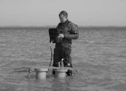
antennas. The general view of the sea version of LOZA GPR
is shown in Fig.1.
|
| Fig.1 Sea version of LOZA GPR. General view |
Archeological Survey
The underwater GPR complex, in combination with the overland version working on the shore, has allowed continuing the researches started in the season of 2000-2001 in the water area of Tamansky bay. In the field season of 2001, a great object lying under water near the shore line in the south-east part of Chushka spit has been detected. GPR researches and digging have revealed a condensed clay basis, about 15 meter wide, and parts armored with fragmentary stone. The object has been completely covered by a layer of sea adjournment as silt, oozy sand and shells.The analysis of the obtained results (structure, geometry and size of the object) has allowed coming out with theassumption that it was the basis of a defensive wall. On the Tamansky peninsula, there are well kept fragments of a wall, known as Kimmerijsky wall. From K.K.Gerts's words, one of the first northern Black Sea researchers Dubo de Monpere has named it Kimmerijsky being based on the indication by Strabon: "During former times, Kimmerik was a city on the peninsula and locked the isthmus by ditch and wall". Gerts informs: 'The south-east border of the Fontan peninsula forms an ancient wall which begins from the extremest north-east corner of Tamansky bay and comes to an end, as people speak, at Azov Sea, station Peresypnaya … The ditch, one and half fathom wide, is still rather deep".
 |
 |
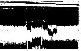
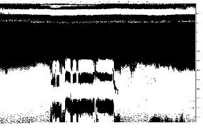
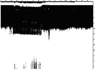
| Fig.2
Cross section at distance 0.3 km. Water depth 0.5m. |
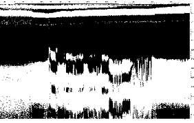
Fig.3 Cross section at distance 0.5 km. Water depth 0.7m. |
Standard GPR cross sections reflecting the structure of the Kimmerijsky wall have been realized at 600, 200 and 100 meters from the water boundary of Tamansky bay in the West-East direction (along the axis of the remaining part of the wall). We have obtained practically identical GPR cross sections during inspection of the extended underwater object near Chushka spit. Dozens of GPR profiles have allowed to trace the object along the distance more than two kilometers from Lisij island up to the cross-arm of Krupinin island east point.
 |
 |
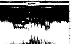
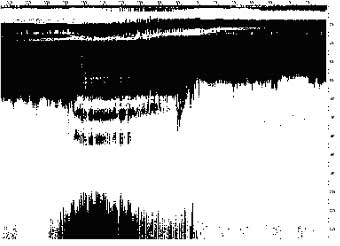
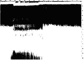
| Fig.4 Cross section at distance 0.7km. Water depth 0.8m. |
Fig.5 Cross section at distance 0.9km. Water depth 1.0m. |
During the season of 2003, in the water area of Tamansky bay west part we have obtained more than 50 underwater GPR crossections on a distance of 12 km. In all cross-sections, under a layer of silt and sand, it has been registered a 15 meter wide basis of a wall, here and there having a stone armor, and a 12 meter wide superficial ditch from the southern side.
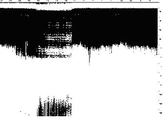
In figures 2-11, some radar cross sections of the Kimmerijsky wall, obtained from sea bottom, are shown. The received radar signal is presented in binary form, without processing, in the return delay range of 0 to 256 ns. Such delay values in this region, according to our estimates, correspond to penetration depths around 4 to 6 meter. The distances indicated in the figure captions correspond to the separation from the shore at the point where the wall crosses the shore line. These figures allow one to trace the degree of destruction of the wall structure by the sea storms. So, in Figs. 2-3 one can easily observe the traces of the groundwork stones and a ditch at the right side of the wall. Beginning from Fig.4, the ditch cannot be seen, and from Fig.6 the stones disappear, evidently, gone with water flow. Here, one can observe just a clay wall foundation.
The sizes of the wall and the ditch are a basis of our conclusion about the identity of the detected by UGPR object to the existing in our time Kimmerijsky wall. We believe, that in the past it was an entire defense construction described by Strabo (Book 11, Chapter 2).
 |
 |
| Fig.6 Cross section at distance 1.1km. Water depth 1.2m. |
Fig.7 Cross section at distance 1.3km. Water depth 1.9m. |
 |
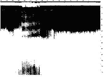 |
| Fig.8 Cross section at distance 1.5km. Water depth 2m. |
Fig.9 Cross section at distance 1.7km. Water depth 1.9m. |
 |
 |
| Fig.10 Cross section at distance 10.8km. Water depth 2.2m. |
Fig.11 Cross section at distance 11km. Water depth 2.5m. |
References
- A.G Vasiliev, V.V. Kopeikin, P.A. Morozov. GPR in underwater archeologic researches. Antiquities of Bosphor. N5. 2002. M., in Russian.
- Antiquities of Kimeric Bosporus. Publishing house " Hermitage ", SPb, 1854, V.1, p. СХХХIV, in Russian.
- V.D. Blavatsky. Essay of military science in the northern Black Sea antique states. Issue of AS the USSR, Moscow, 1954, p. 103, in Russian.
- K.K.Gerts, Archeologic topography of Tamansky peninsula. M. 1870, p. 103, in Russian.
- Strabo. Geography. Translation by G.A.Stratanovsky. M., 1994, p. 494, in Russian.
- Dubois de Montpereux. Voyage autour du Caucase. Paris, 1843, AtlasV, p.34, in Franch.